Tag Archives: Ensenada free road map

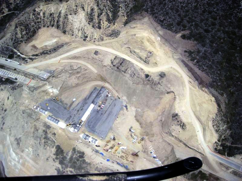
Toll Road Sand Pit


tollrddk1

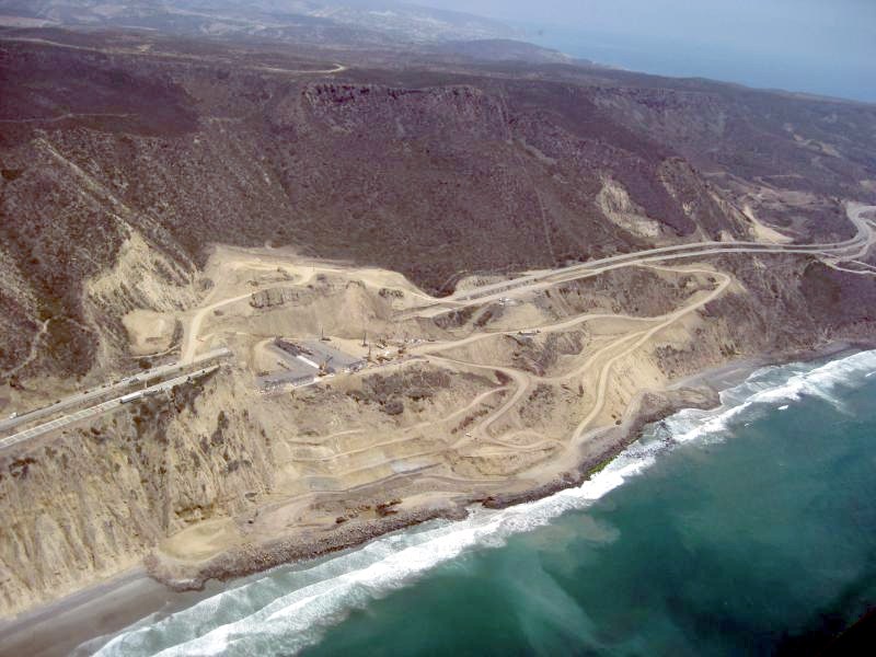
tollrddk2

Thanks to David K of Bajanomad Forums for posting these helicopter photo shots of the Ensenada Toll Road Repair.  Photos shot Tuesday, June 24, 2014.

As written previously, my pro background is in sales, and I’m no engineer nor geo rock guy.  But, wowzers, the landslide area sure does look like a big sand pit that wants to melt into the ocean.

I also like the terracing for the condo projects in top photo, that will hang above the beach.  Before the slide, Cuatro Cuatros said that they owned part of the beach in the area.  Cuatro Cuatros’ ranch property, winery, restaurant and a couple of their picnic perches are just above the slide.

Can’t find documentation, but, some forum discussion indicates that there will be 2 lanes, one northbound, one southbound, climbing and circumventing the slide for the September 15 reopening.  It will supposedly take a year to re-construct the original highway path here.  Anyone confirm with documentation from CAPUFE or other source?

What’s the over/under on the new toll fee at the ‘Nada toll booth?
freeroadmap

Ensenada Free Road Detour


freeroadmap

My trip southbound yesterday on Free Road Detour was easy.   It took 45 minutes from La Mision exit to Free Road to return to Hwy 1 at the ‘Nada toll booth.  That is approximately 8-10 minutes longer than normal due to moderate traffic Sunday.

Only quirk was the rerouting U turn at the end southbound.  I was directed on a 200m jog north toward the toll booth, then U turn south(map below).  Either they are working on that bridge or the tiendas and restaurants(San Miguel and Boules) paid someone to create the detour toward their businesses.  8)~

enstollboothuturn

Several forums and Facebook posts have discussed other detours to shorten the current Free Road Detour.  One suggested an eastern exit from the toll road at Bajamar, connecting with Free Road at Rancho Las Chichihuas.  At least part of that pavement is done, as Chichihuas has a nice tennis court.

chichihuasmap

chichihuastennis

Ensenada Toll Road Slide


Editor’s note, 9AM PDT UPDATE: Ensenada Tope Grande!  Apparently, the Toll Road has slid further(can grammar police help me here?), sometime during the night.  Hope nobody was hurt, or worse.  This will end the weekly asphalt patching and force Mexico to figure out long term routing, likely via Free Road. 

Construction on Free Road also caused delays.  Red highlight on map, a few miles north of the ‘Nada toll booth is where the asphalt adventure is located.Coming south, Free Road access is at La Mision/La Fonda exit and rejoins hwy 1 just 400 yds south of the Ensenada toll booth.  It will only take you a few minutes longer, so enjoy the beautiful inland countryside.  Free road map below.

So, Fluffy, you were worried about your perfect souffle and cheesecake textures for your tea party today?

Like Butch and Sundance, “Swim?  The fall will probably kill you.”  You won’t get out of Tijuana with your head attached to your body, so why worry about a little land slide?

salsipuedes

El Mexicano article

The Scenic Road recorded four new sinkings this day, one of more than 60 inches in both directions of the road.

The flaws have caused long lines of cars, especially Tijuana to Ensenada, a 93 kilometer.

Reported waiting up to half an hour to cross this stretch, since only one of the two lanes, the low speed (right), has been enabled for the crossing.

The subsidence in the two lanes of Tijuana to Ensenada already been repaired, but in the opposite direction still continue to work.

Complaints of drivers have been expected, especially because nobody tells them the state of the roads, but they have to pay their full toll, despite the delays that this generates.

freeroadmap

Editor: WOW

ensenadahighwayslideupdate

foto de El Vigia

enstollroadslide

Ensenada Toll Road Slide shows before(yellow lines) and after. OUCH!